Epilogue 2 2016 Summary Stats
I was an engineer by training and spent 30+ years working around Information Technology. I am a very analytical person. If you tell me your name, it will fall out of the memory buffer in less than 30 seconds. Numbers, on the other hand are very sticky to me. I still remember the first phone number I had to learn in kindergarten (Skyline 5 1498). With that as an introduction, here is a more or less accurate summary of the ride. I say more or less because the sensor on my bike computer failed as I was leaving Columbia, MO, so I didn’t have accurate information about anything related to mileage, ride time, or speed until it was replaced in Indianapolis. It certainly didn’t stop me, but being the slightly OCD/anal person that I am, it drove me crazy not knowing the mileage or total ride time. It would be like Dr. Sheldon Cooper not being able to sit in his favorite spot or only knocking on the door only once. At any rate, there were five days when I was blind to that data. The larger implication was that it made it harder to navigate my path without accurately knowing how far the next turn would be. And I did miss a few turns or need to take some detours. Speaking of detours, the original route was to be approximately 3,015 miles and finish in Annapolis, MD. The actual route probably came closer to 2,950 miles with a shorter finish in Baltimore due to a snapped chain on the last day.
So for all the data nerds out there, the quick summary was 43 days end to end, with 41 days on the bike. I stayed an extra day in Wichita trying to wait out a heavy rain. I rode out the next day thinking it was over and got soaked for most of the morning. With 75% of the miles under my belt, I also stayed an extra day in Indianapolis taking care of both bike and home maintenance. This works out to an average of about 72 miles per day. I had 2 short days of 41 miles and the final push to Baltimore ended up being only 37 miles. The longest day was 101 miles, partly because I had to double back to retrieve my flexible phone/camera tripod I had forgotten at a marker in Dodge City, KS. At the last minute, I decided to press on from Jacksonville, IL to Springfield, IL, extending that day’s ride to 98 miles. There were 10 other days that lasted 80 miles or more. 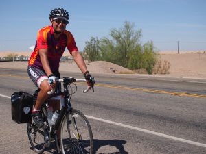
For those 2,950 miles, I was on the bike for about 226.6 hours. The average speed, while on the bike comes out to about 13.02 mph over the course of the entire ride. The fastest day was the second day, when Becky was carrying my panniers. After climbing 4,000 feet on day one, I was dropping down into the desert. There was a constant west – southwest wind of 25 to 35 mph most of the day with some gusts of up to 50 mph. I hit a top speed of 48.69 mph before the wind shifted and I hung on for dear life and wore out the brakes. I averaged 22.06 mph for the day as I felt like a combined Greg Lemond, Eddie Merckx, Lance Armstrong (without the doping). Even though I rode close to 74 miles, it was one of my shortest time-days on the bike. On the other hand, the slowest day was also one of the shortest. The 3,500 foot climb loaded with my panniers was on a narrow road from Sedona to Flagstaff, AZ. There was a lot of Sunday tourist traffic that included wide buses. It was cold and it rained most of the 41 miles. There was snow on the ground near the top. The route I had originally chosen under Google’s guidance didn’t exist when I got to a key turn. It was not my favorite day, but the warm showers hosts helped me forget my suffering over 4 hours on the bike at an average of 9.8 mph. The total time of the ride was probably closer to 5 and a half hours due to pulling off the road for traffic, finding some shelter from the rain for a few minutes, and some brief rest stops.
The highest elevation was 10,800 feet crossing the Western Continental divide at Wolf Creek Pass, CO. It was close to a 4,000 ft. climb out of Pagosa Springs. Snow started falling 8 miles from the summit and I was so glad to have my brother, Mike there for me at the top. We put the bike into his car after conquering the climb while someone else was unloading a snowmobile. After driving 17 miles to the bottom, I finished the shortened 53 mile day. Obviously I was at sea level at the start and finish, but on the second day I had dropped into the desert around 170 feet below sea level.
It got down to about 21F at the top of Wolf Creek Pass, but was also near freezing on the second morning in Julian, CA and at 7,000 feet in Flagstaff, AZ. The desert ride in California was in the low 80s, along with the lonely stretch from Southern Utah into Cortez, CO. I got some 90 degree days as I hit eastern Ohio and into Pennsylvania. Besides the rain in AZ, the worst was the wind in Kansas. Although the weather pattern moved west to east, the winds were almost always out of the north, northeast, or east. I had headwinds without break for far too many miles and I just wasn’t expecting it.
All nights were in hotel and motels. I did get to have the hospitality of 6 Warm Showers hosts. Warm Showers is a network of hospitality homes for cyclists, by cyclists. I also spent one of my favorite nights in London, OH at Andrea’s Bed and Breakfast. The owner also had a few “hostel rooms where you shared a room that had bunk beds and used a shared bathroom and shower. The best part was you still got her breakfast which was other worldly good. I’ll have to look at my bank records more thoroughly, but off the top of my head, the most expensive stay was one of the only hotels in the Navajo Reservation town of Tuba City, AZ. Not only was it one of the most expensive, I paid for my one night twice because I just missed the cancellation deadline. That’s what happens when you don’t have cell service in remote areas. 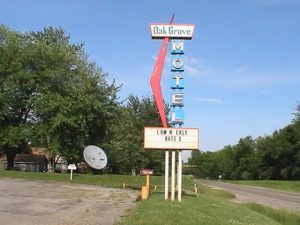 The cheapest hotel was in Foster, IN. While it wasn’t dirty, it certainly showed its age. I got what I paid for – $35 cash for one night. It was all part of the adventure.
The Lone Rider
The tabular format of all this data will be available in a different post.
Leave a Reply